Automatic Position Reporting System - APRS
APRS is an amateur radio system originally developed to maintain an ongoing record of the location of a mobile radio-transmitter. It has been expanded to allow reporting of weather information within a position report. Originally restricted to reporting via amateur radio, it is now possible to send (and receive) these reports via the Internet.

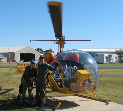
Bell 47 crew: Connie VK2CON (left) and Yves VK2AUJ/VE2AUJ
Amateur Radio use of APRS
APRS is used by amateur radio operators to transmit real-time position information, weather data, telemetry and messages over the radio. A vehicle equipped with a GPS receiver, a VHF transmitter or HF transceiver and a small computer device called a tracker transmits it's location, speed and course in a small data packet, which is then received by a nearby iGate receiving site which forwards the packet on the Internet. Systems connected to the Internet can send information on the APRS-IS without a radio transmitter, or collect and display information transmitted anywhere in the world.
APRS is used to plot the positions of mobile amateur radio stations. Typically this is a car, but it could be a boat, plane or helicopter. The APRS.fi website shows the positions of many radio operators in near real time.
There is even an APRS transmitter in a helicopter, click to see it's current position and recent trips. This is the helicopter that is planning to visit us at Narrabeen, we will be able to track its location in real time as it approaches our site.
The helicopter is a Bell 47, as shown in the photo. For many more photos of this type of helicopter see the Bell 47 Helicopter Association website.
Universal Shipborne Automatic Identification System (AIS)
No, it's not the institute of sport, the Automatic Identification System (AIS) is a fairly new tool that dramatically changes the way ships are tracked. An AIS transponder uses VHF frequencies, and broadcasts your own vessel's position, name, callsign, along with detailed parameters like length, beam, draft, and tonnage. It also broadcasts details of the current navigation system: speed, course, rate of turn, destination, and ETA.
The transponder receives this same information from other ships, and either displays it on its own screen or emits it in an NMEA-standard data stream for use by chart plotters and other onboard navigation gear. The positions and intentions of nearby vessels are available unambiguously and in real time.
The US Coast Guard Navigation Center has a summary of AIS technical details.
Read more about AIS and view current global ship positions at one of these or many other websites:
